James ‘Jim’ Beardsley has contributed many photos to the Old Ilkeston site from his collection, gathered over many years resulting from his interest in local history photography.
Jim was a builder by trade before he retired, part of a long family line of Ilkeston Beardsley craftsmen responsible for building, repairing, and renovating numerous properties around the town over many, many years. During that time his family has built up an extensive archive of documents, associated with these premises. Several of the documents have been used within the Old Ilkeston pages.
This section brings together the Beardsley documents. It concentrates upon the maps, plans and illustrations within them; there is a lot of legalese which accompanies them and which I have omitted. You will find a more detailed account of many of them within the Old Ilkeston site.
The papers are in alphabetical order and who knows … the list may contain your own property, one you once owned or one you have a particular interest in ? You may recognise the name of someone you know ?
______________________________________________________________________
Albert Street and West Street area (1860-1980s)
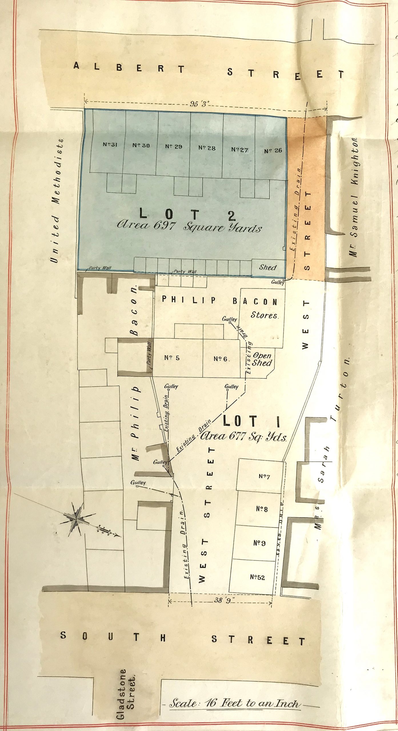
from a conveyance document dated 11th December, 1895
This 1895 map (left) appears at the end of a sequence of documents.
The first document is dated January 16th, 1860.
The collection outlines the history of the properties within West Street, lying between South Street and Albert Street.
It introduces us to Richard Fritchley of Cossall, John Hardy of Kirk Hallam, William Wade of Ilkeston, Joseph Marsh of Wirksworth, William Argile of Quarndon, William Hall and William Burrell of Belper, Philip Bacon, Samuel Robinson and George D Knighton, all of Ilkeston.
All these people had an interest in this area. either owning or occupying property.
The whole of this collection is examined extensively in the Old Ilkeston site to describe the area of Wide Yard/West Street
The last documents in the sequence, dated in the 1980s, relate to the houses of 26-31 Albert Street, at that street’s junction with West Street.
These Albert Street properties were at that time owned by Jim Beardsley.
______________________________________________________________________
Bath Street .. part of (1852-1899)
On May 10th, 1852 John Ball, lace manufacturer of Burr Lane bought a piece of land on the west side of Bath Street from the estate of the Duke of Rutland (and co.), measured at approximately 1091 square yards. It had recently been occupied by Joseph Daykin, a Chelsea Pensioner.
The document outlines the “neighbours” of this piece of land at that time: — on the north was an area of land owned by John Ross, an auctioneer and land appraiser; on the south was land which had just been bought by John Daykin, a lace agent and the son of Joseph (in an area later known as Daykin’s Row) ; on the east was Bath Street; and on the west was a narrow lane leading from Bath Street down to the Manor House or Ilkeston Hall … this was known as Spring Lane but today we would know it as Wilmot Street leading into Fullwood Street which follow the same route as that lane. The lane can be seen on William Gauntley’s Enclosure map of 1798.
On June 29th, 1867 John Ball sold the land to William Lacy Bostock, a mining contractor of Mundy Street. By that time neighbour/owner John Ross had been replaced by Mark Beardsley and some of the original land had been sold to Joshua Bates and then to Joseph Hayes; in the south, owner John Daykin had been joined by John Richards. And the area of the plot was now estimated to be 1000 square yards.
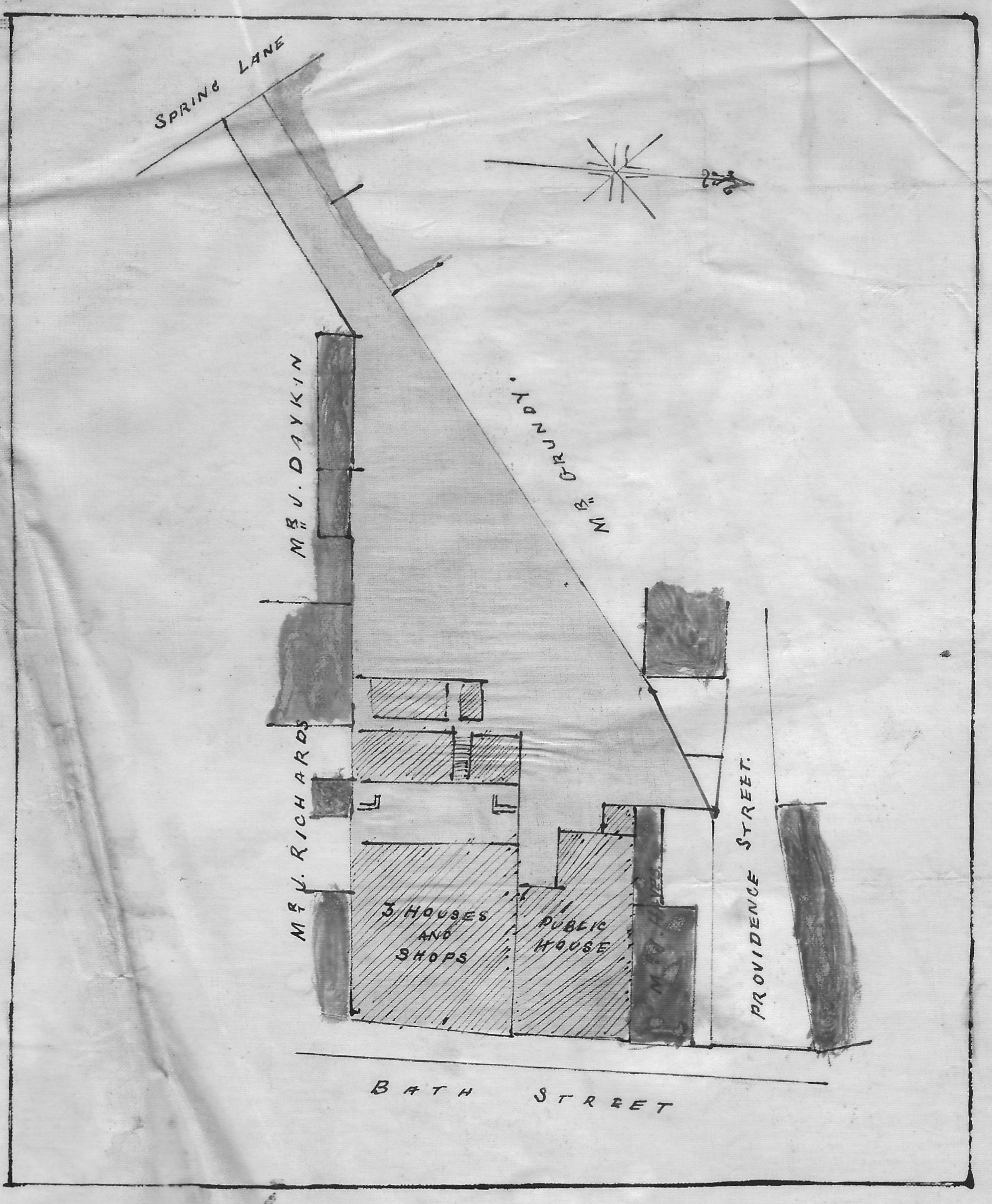
plan of the area in 1867 showing the site of the New Inn
As the plan above shows, John Ball’s original plot had been developed; three dwellings with shops had been built as well as a Public beerhouse with brewhouse, stabling etc., later known as the New Inn.
By January 23rd, 1873 William Lacy Bostock, who had taken out a mortgage to buy the property, was owing money on that mortgage to the mortgagees. As was stated under the terms of their agreement, the mortgagees were therefore entitled to sell the property to recover their loan, and this they did …. and in this way the property passed to James Bonsall of Ilkeston.
By July 1874 James had paid off any outstanding mortgage and so the property was reconveyed to him. In his will dated April 26th, 1890, it was stated that the New Inn was leased to Messrs Shipstone & Sons, and the landlord was William Trueman. At the rear was a cottage occupied by William Carrier. Both these properties were willed to James’s son Walter who duly inherited them when James Bonsall died on December 16th, 1893. The three houses/shops adjoining the New Inn, then numbered 71,73 and 75 Bath Street and occupied by grocer Thomas Gibson, pork butcher Alexander Mellor Barker and baker and confectioner Thomas Adlington respectively, were left to James’s daughter Hannah Hodgson, the wife of Frederic of Tupton Woodthorpe, whom she had married in 1862.
On February 4th, 1899 Walter Bonsall sold off the cottage at the rear of the New Inn (with its frontage to Wilmot Street) to Robert Widdowson. By that time William Carrier was no longer living there; it had subsequently been occupied by William Thorpe. At that time a sketch plan was produced to show the holders of property in this area, and therefore the neighbours of the New Inn.
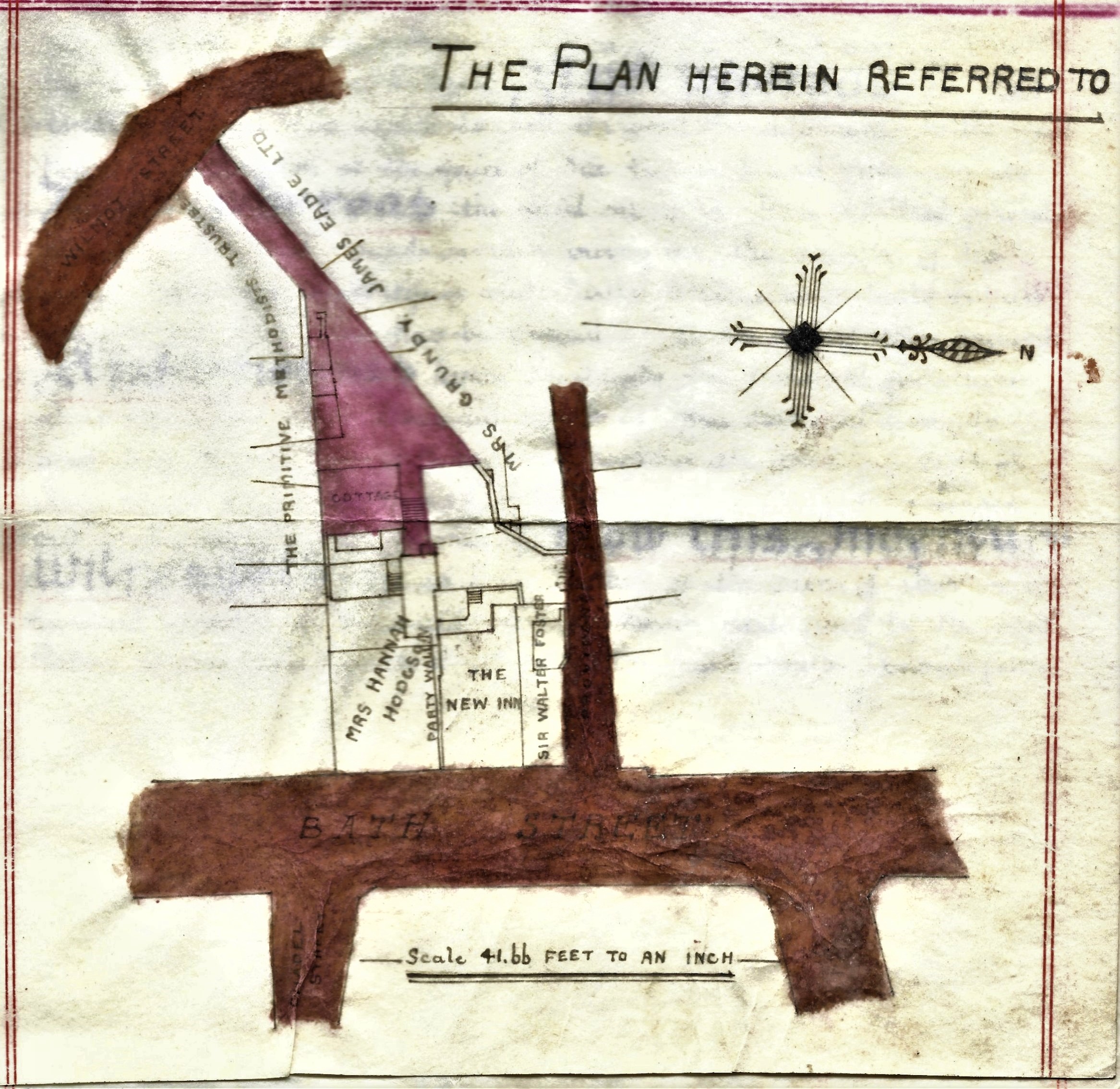
The New Inn area in 1899
As we have seen (above) in his will, James Bonsall left three premises, with their yards and outbuildings to his daughter Hannah Hodgson. She had married farmer Frederic Hodgson in 1862 and lived on the family estate at Woodthorpe near Chesterfield. These houses lay just to the south of the New Inn and were then occupied by baker and confectioner Thomas Adlington who had married Amelia, the youngest daughter of James Bonsall, in 1886; pork butcher Alexander Mellor ‘Alic’ Barker; and grocer Thomas Gibson. The three properties were numbered 75, 73 and 71 Bath Street respectively. Number 79 was in the possession of Sir Walter Foster, MP for Ilkeston; it was home to the Lee family. Reuben Lee was a fried fish dealer; also a potato dealer, and later a newsagent.
______________________________________________________________________
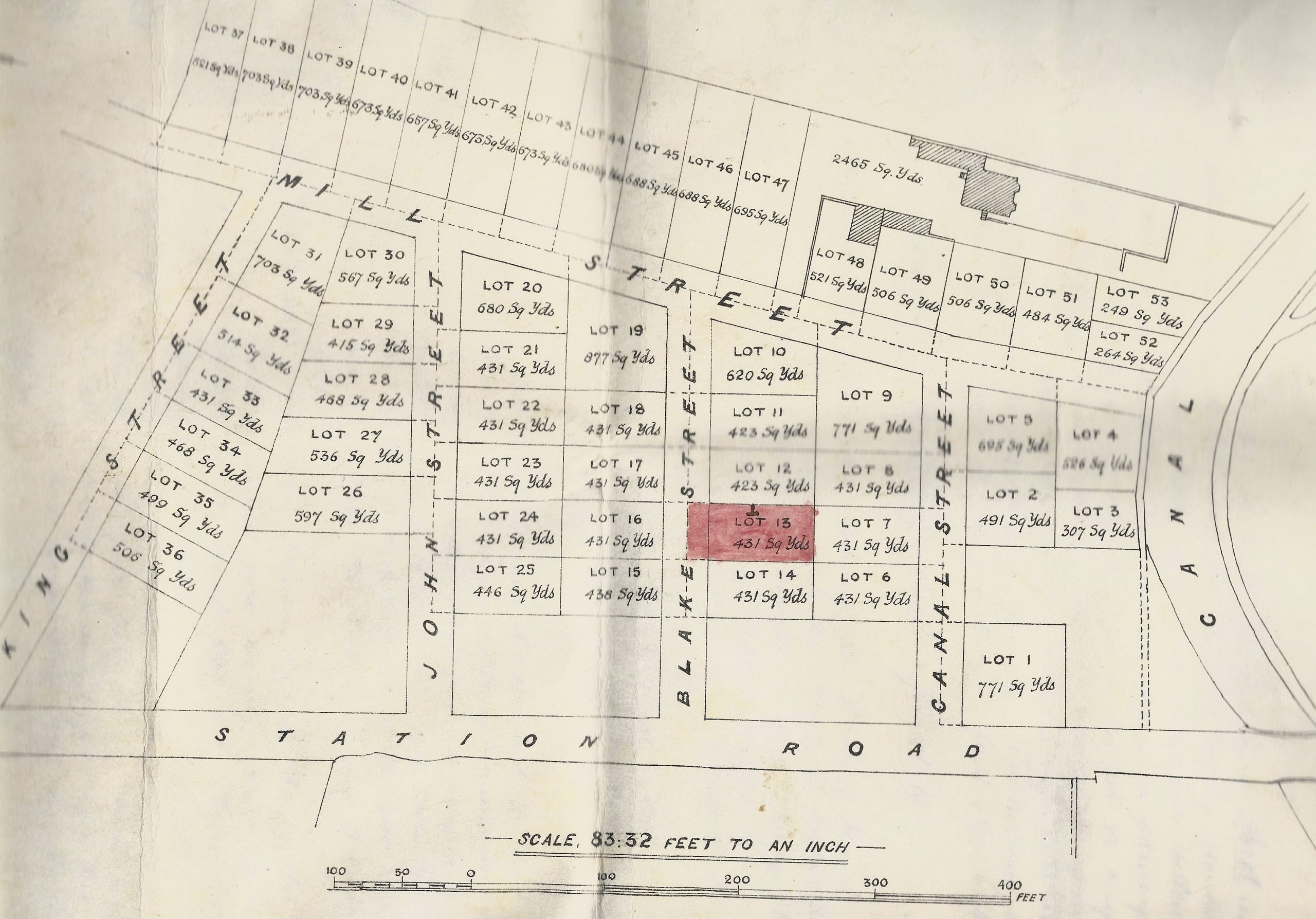
Blake Street (1882-1982)
The first document begins at December 18th, 1882 and ends at 1895
It introduces us to Henry Abel Smith of Nottingham, Charles Hiram Gregory and William Hewitt, both of Ilkeston, Laban Bexford of Old Basford, Isaiah Bexon of Nottingham, Henry Knighton and George Wright, both of Ilkeston, William F Goodliffe of Woodthorpe House and Theobald Alexander of Nottingham.
Later documents bring in Moses Fulwood of Bath Street, Thomas Fritchley of Ilkeston, Louisa Fullwood (sic) wife of Moses and Walter Beighton of Kingsway, Ilkeston up to 1897.
Plan of the Blake Street area from a conveyance document, dated April 24th, 1895, between Henry Knighton, George Wright and Moses Fulwood
Subsequent documents dated 1917 to 1982/3 and thus outside the Victorian period, bring in Angelina Hockley, wife of Henry Hockley of the Black Boy Hotel, Mansfield and later of Lenton, Nottingham, William Ellis senior, William Ellis junior of Cotmanhay Road, Alice and Eliza Ellis of Derby Road.
The final document, dated 1982, brings in Elsie Davies, Gladys Margery Haffner and Clara Irene Smith, owners of 29 Blake Street.
______________________________________________________________________
Burr Lane (1884-1982)
At a public auction held at the Old Wine Vaults on March 6th, 1884, John Ball, a lace manufacturer of Dodson House in Burr Lane bought a couple of properties (Lot 4) in his own back yard.
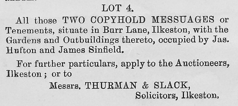
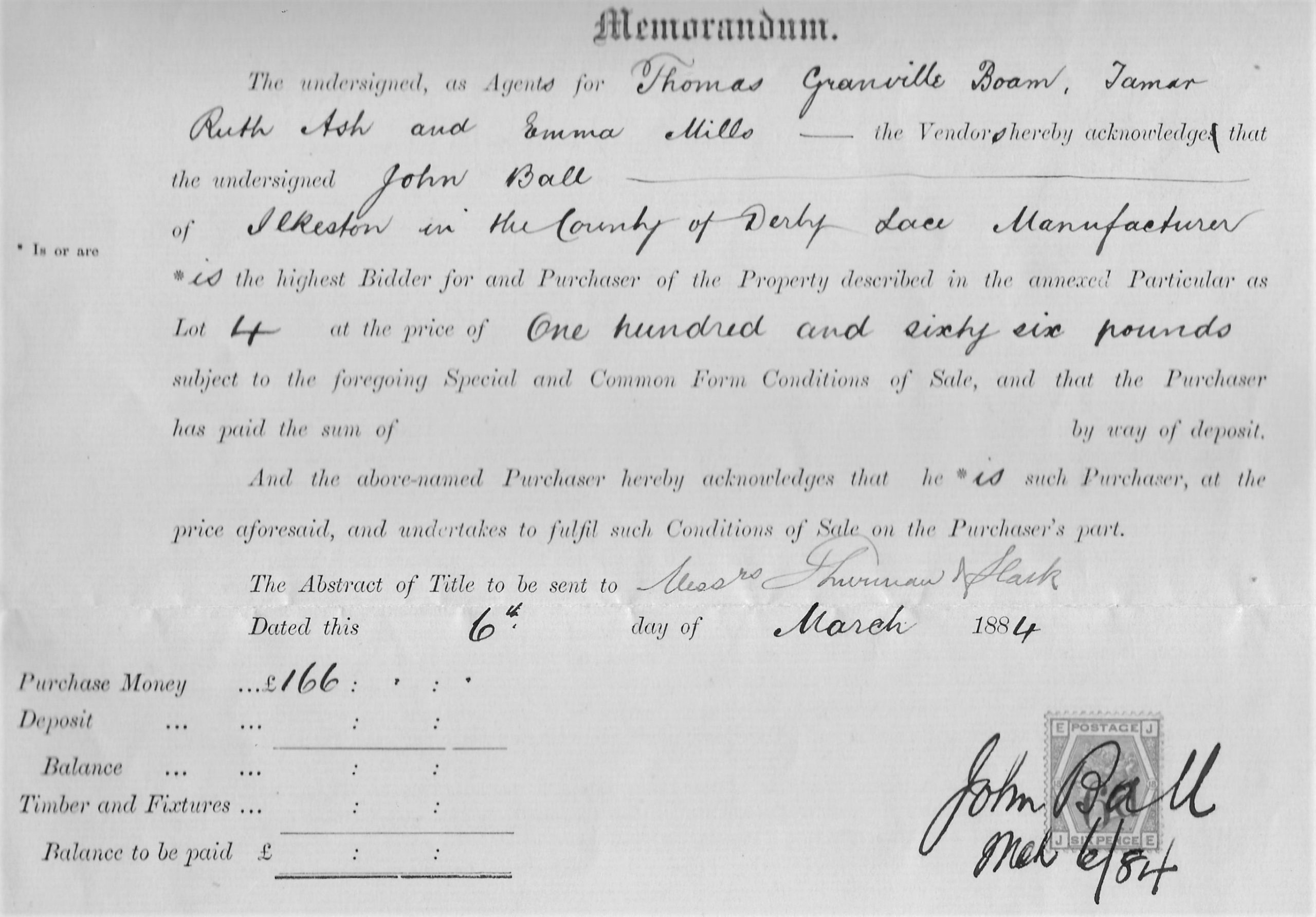
In the will of Thomas Trueman, who had died on January 6th, 1846, these two properties had been left to Thomas’s daughter Tamar and when she died they were to be passed to her husband Samuel Boam (if he survived her).
Tamar died in 1861 and Samuel in 1883.
The two premises then passed to the surviving Boam children, Thomas Granville, Emma and Ruth Tamar.
It was they who were selling the property in 1884.
Post Victorian Documents
Other Burr Lane documents date from 1935, relating to houses owned by Charlesworth Bennett Wood (1873-1935) of Dodson House.
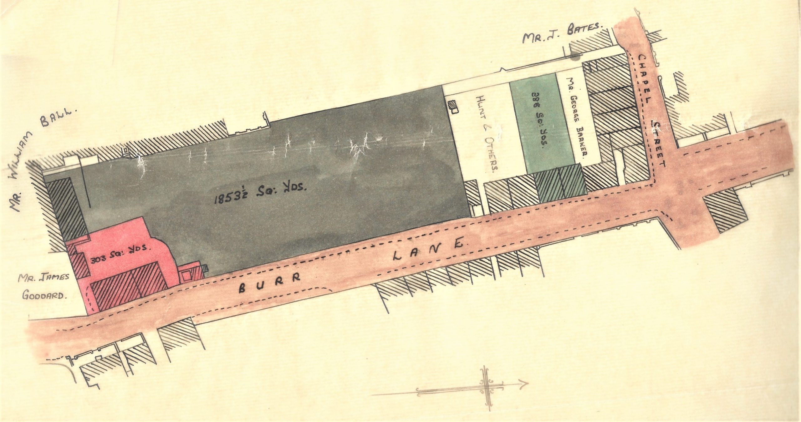
They include detail of how John Ball took an interest in other Burr Lane property in 1891 and what happened to this up to 1935 when they appear in the estate of Charlesworth Bennett Wood.
From this estate, numbers 27 to 32 of Burr Lane were sold to John Thomas Lally then living at Whitworth Road.
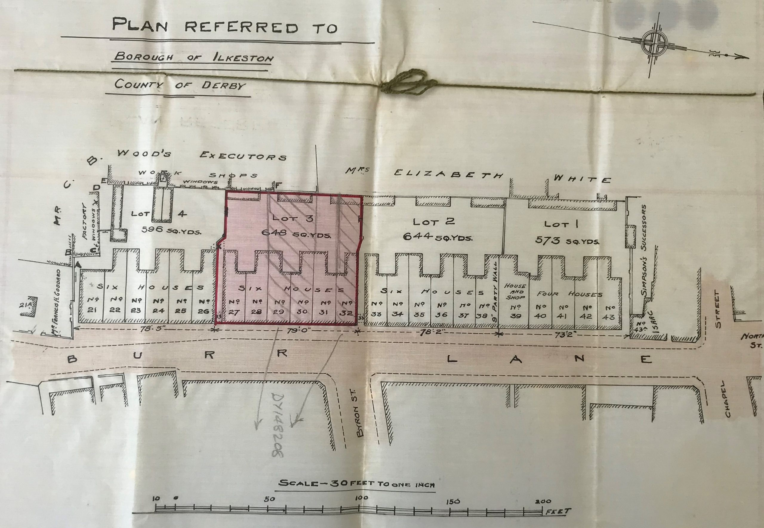
There is additional detail of what how John Lally disposed of some of these propeties up to 1982
______________________________________________________________________
Gordon Street (1885-1905)
All the documents in this bundle are ‘post-Victorian’ but parts of their contents give glimpses into this area at the end of the Victorian period. I will concentrate, like the documents do, on the Shaw family.
We start at November 6th, 1885 when Samuel Shaw took a part interest in property in this area. Born in Kimberley, he appeared in Ilkeston after his marriage to Ilkeston-born Jane Smith on August 7th, 1854. For the rest of his life he lived in the New Street/Station Road/North Street/Chapel Street area. In 1894 his son Samuel the younger (born in 1862) joined the story and in 1901 he was joined by his younger brothers Joseph William (born 1864) and Isaac (born 1866).
The property they were interested in was shown in the plan below and in 1904 was held solely by Samuel Shaw the younger. His father had just died (on January 4th, 1904)
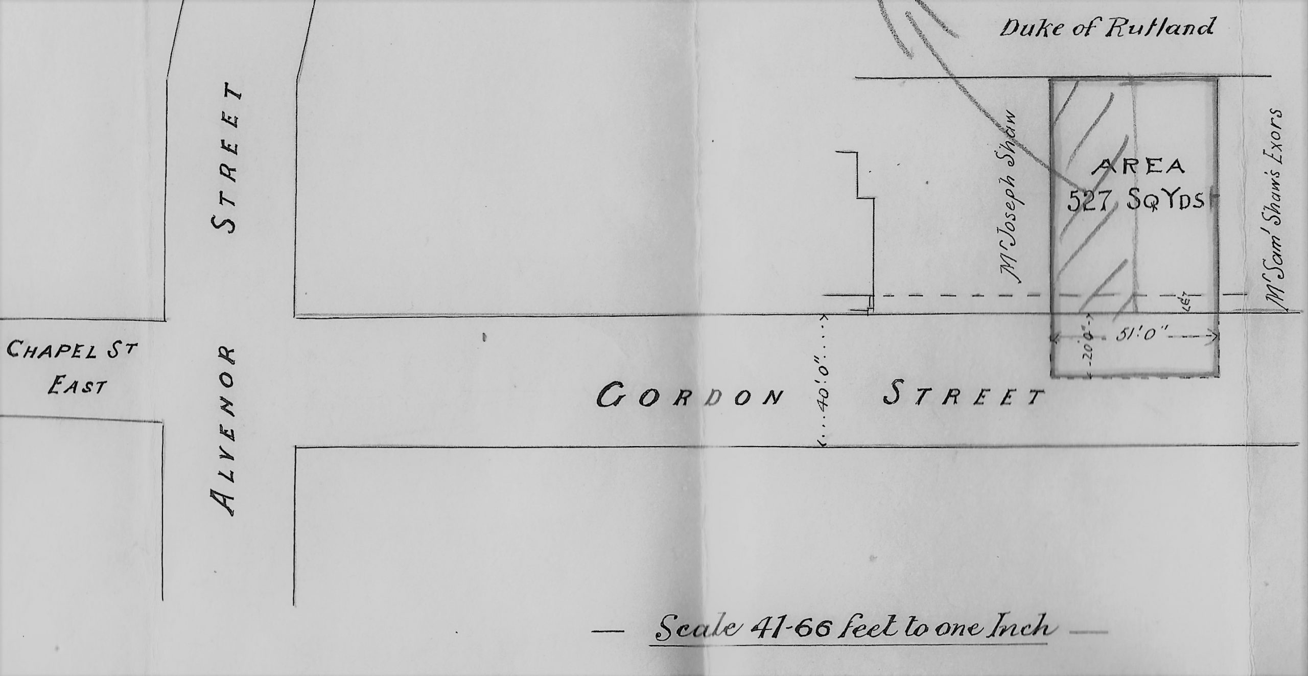
from a conveyance document dated December 31st, 1904
A month later Samuel the younger sold the property to his brother Joseph William.
On the plan above dated 1905, the late Samuel Shaw’s estate is within the boundary marked with a red/purple line. It show how the area was developed by the Shaw family. Eight houses, erected in Lower Chapel Street, are numbered, along with a few neighbouring ones. Present-day Rupert Street is marked as Clarence Street – why ? — it could be that Gordon Street and Clarence Street were both named after Samuel’s grandson, Clarence Gordon Shaw, born in 1892, (son of Samuel Shaw junior). Clarence Street later changed its name of course.
______________________________________________________________________
Nottingham Road and Shipstone Street (1871-1921)
If you walked to the bottom of Nottingham Road, just after it crosses over the Erewash Canal, on the north side you would see the Gallows Inn public house, and adjacent to it is the large yard of KRM Building Supplies. However if you made the same journey 150 years ago, you would find no ‘pub’ with that name nor any sign of a retail complex. Instead you would see the Horse and Groom Inn at the side of which would be open fields. This was an area known as “Bridge Close“.
In 1871 this property was in the hands of the Attenborough family (having been passed from Mark to his son Isaac) and when Isaac died in 1894 his widow Lydia (his second wife) and his son Mark (by his first wife Sarah) passed the property on to Thomas Shipstone, a brewer of Edwalton, Nottingham in 1896.
Then, on July 1st, 1899 part of this land was bought by Walter Scott, a builder living in Larklands, Ilkeston.
From a document dated 1971 the sketch (right) shows …
a turnpike road on its left known as Nottingham Road
above the ‘Horse and Groom’ is the Erewash Canal and towpath at its side
Shipstone Street but no buildings on it
and an area of 3065 square yards purchased by Walter Scott, builder.
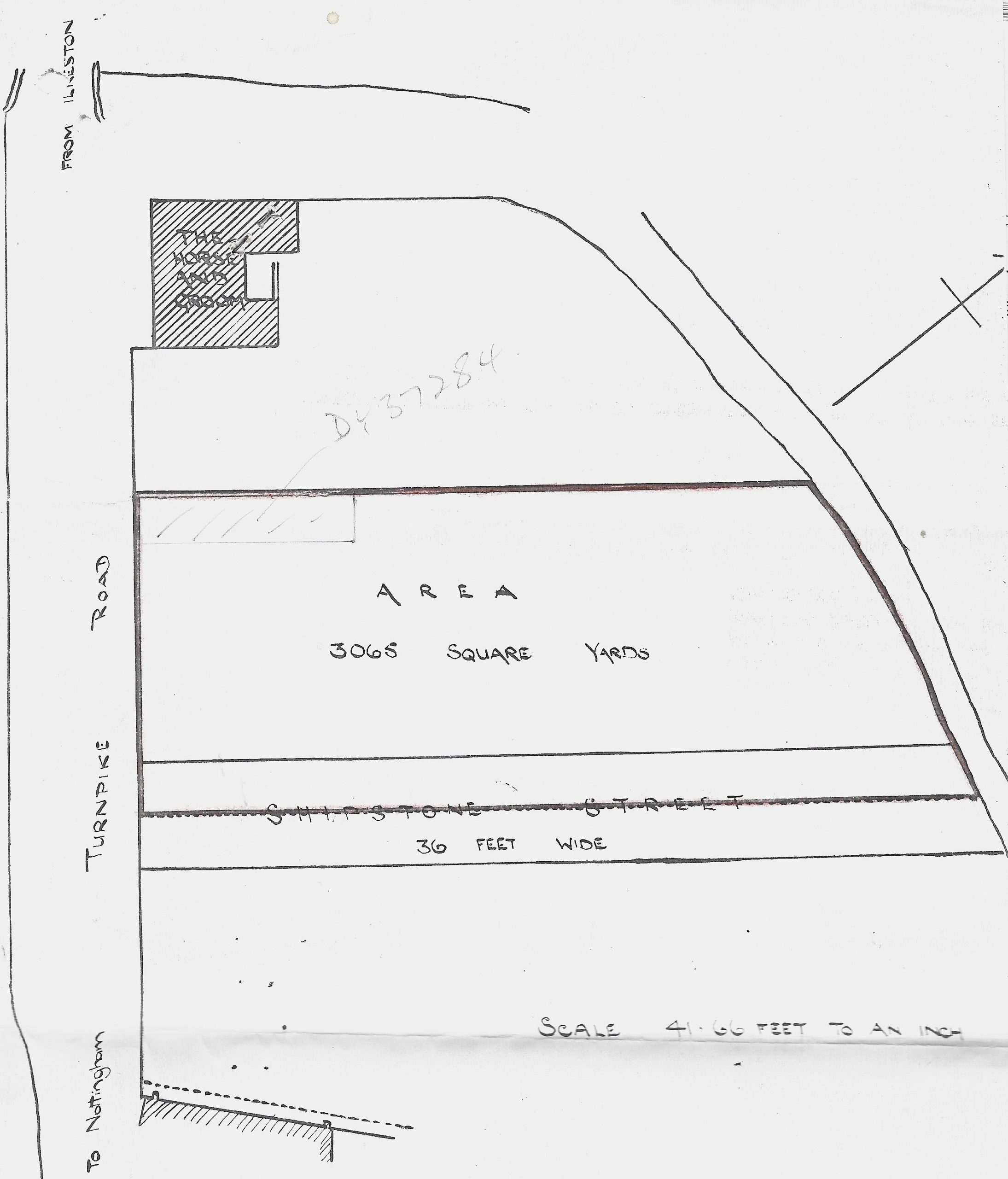
the proposed Shipstone Street in 1899
By 1901 building had started on Shipstone Street where 20 houses were planned. Some had been or were being built on the street while seven of them had a frontage nto Nottingham Road. This latter group can be seen on the 1901 Ilkeston Census (numbered 183, 184a, 185a, 186a, 187a, 188a, and 189a) while on Shipstone Street three houses were already occupied and another seven were ‘being built‘, and three not yet started. These were planned to be numbers 1-13.
Just after the 1901 census all the houses appear to have been finished, their occupiers being “Freeman, Neale, Towle, Freeman, Hartshorn, Potter, Tilford, Beeby, Burton, Hemming, Storey, Beck and Grainger”. At this point Walter Scott took out a mortgage and the properties passed to the control of mortgager James Cochrane Cleland of Albany House in Dumfries.
In 1919 they were reconveyed to Walter Scott who died in December 1921, at 50 St. Mary Street. The properties then remained in the hands of members of his family
______________________________________________________________________
Roberts Street (1891-1977)
As the Vctorian era came to a close, down at the bottom of Nottingham Road, on its north side, lay a piece of copyhold land, contained within a close, long known as Whinney Hill. It had previously been owned by John Wakefield and John Wilson, and then in 1891 by William Shaw of Heyworth Farm in Sandiacre. By 1891 William had enfranchised this land, a process which converted the land from copyhold to freehold (and gave the owner associated benefits). This area of land is shown on the plan below, contained within the blue border.
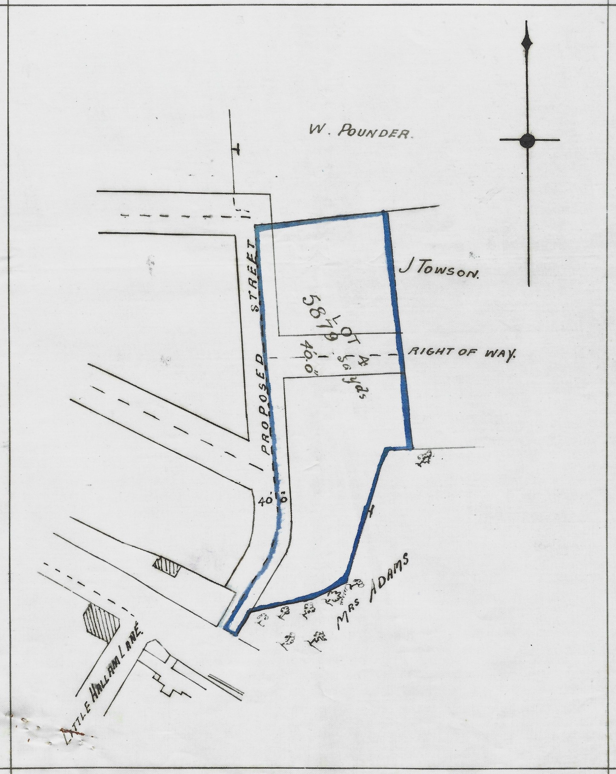
plan of the enfranchised area mapped about 1894
You will see that the area had yet to be developed, only proposed streets being laid out. In the years following the enfranchisement several parts of the original area were sold; for example (but not exclusively) to William Holbrook, Thomas Horridge, A. Cox, John Moss Towson and William Pounder. By 1899 George Goode, a coal merchant of Bobbers Mill, Nottingham had acquired part of it.
On August 15th, 1903 George Goode sold his portion of the land to Thomas Reeve, a builder living in Alvenor Street. It was then described as “having a frontage to Marsden Street formerly Roberts Street” and “of about 1527 square yards” and was a part of the area bordered in blue on the plan above. That part is coloured pink in the plan below.
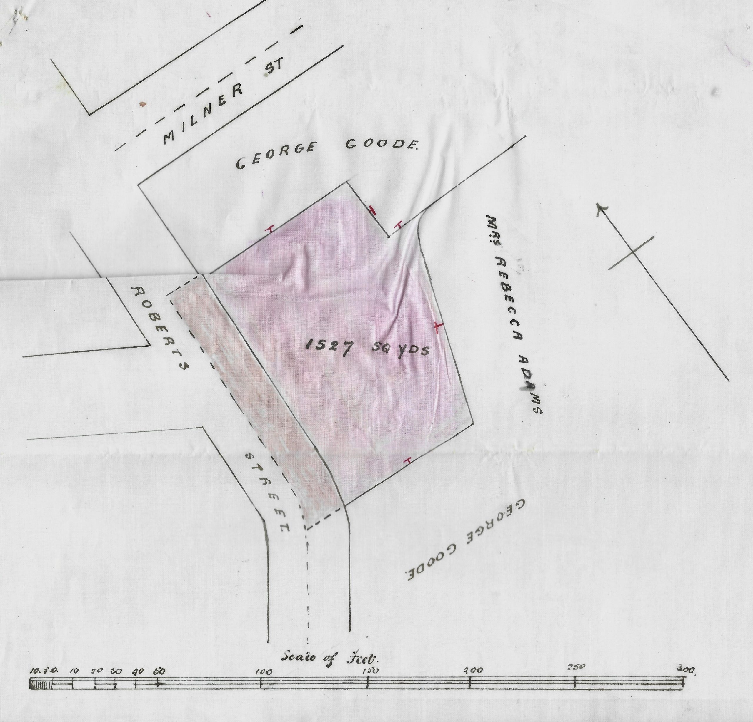
taken from a conveyance document dated August 15th, 1903
On October 1st, 1903 Thomas Reeve sold a piece of his land, now described as in “Marsden Street, originally known as Roberts Street”, to Frederick Gregory, a builder of Mill Street. It measured 528 square yards approximately, part of the larger peice of 1527 square yards which had previously just been sold to Thomas by George Goode. The position of this land and the neighbours surrounding it in 1903 is shown in the plan below.
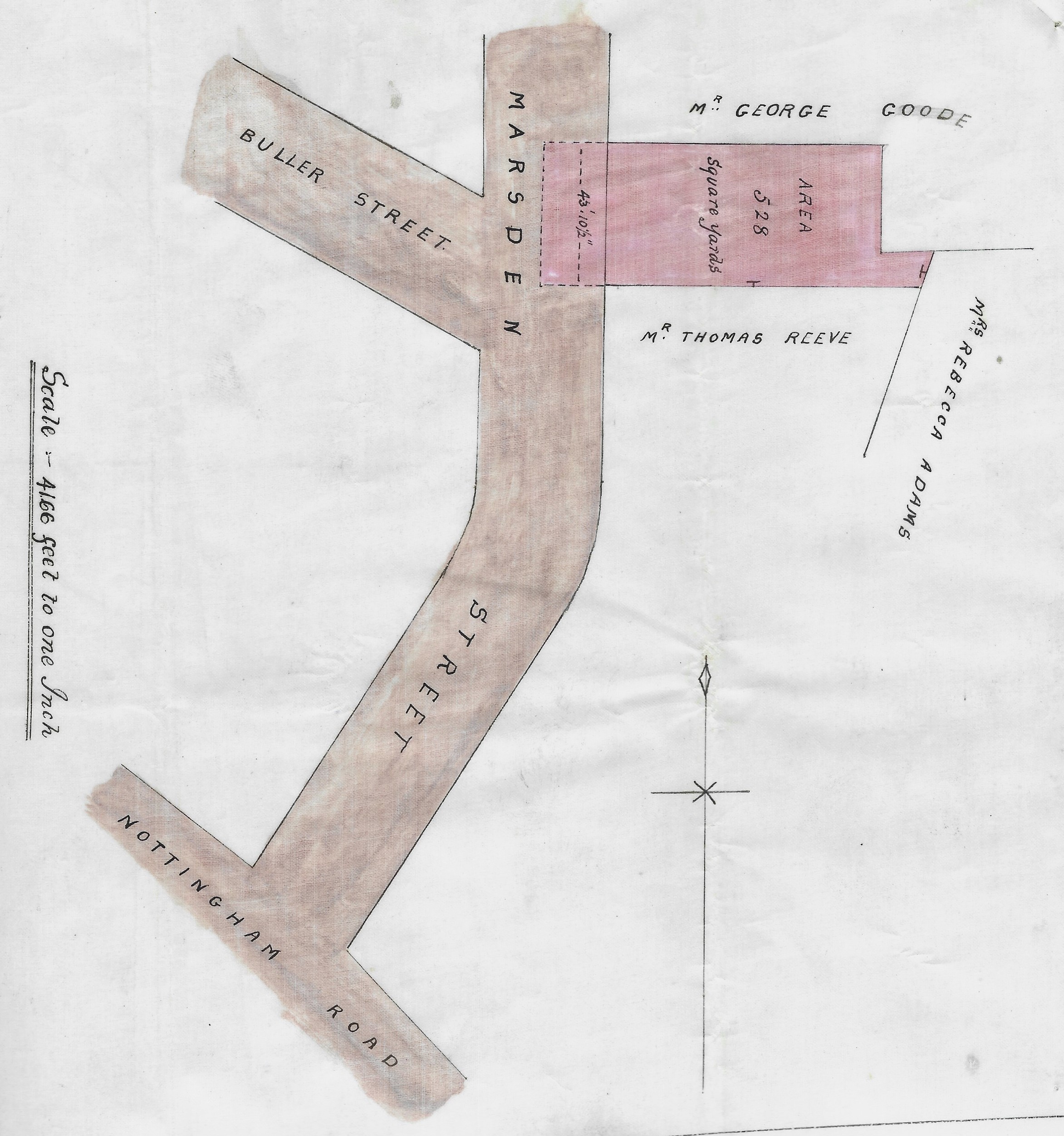
taken from a conveyance document dated October 1st, 1903
On December 19th, 1903 Frederick Gregory mortgaged his property in Marsden Street, a mortgage which subsequently passed through other hands until it was eventually reconveyed to Frederick on February 21st, 1919. Up to 1906 the name”Marsden Street” was used within the documents but by 1919 that name had changed back to “Roberts Street“. On February 22nd, 1919 Frederick sold the property to William Noble of the Nag’s Head Inn on South Street, by which time the builder had erected three dwellings on his land. They were numbered 20, 22 and 24 Roberts Street.
William Noble later moved from the Nag’s Head to the Jolly Farmer’s Inn at Ruddington, and from there on June 28th, 1933 he sold his three houses in Roberts Street to Alfred Keadell of 29 Norman Street. The Keadell family sold number 24 in 1954 and then number 22 in 1956 (to Albert Edward Perkins). In 1966 number 20 was sold to Ada Hardy and remained in the Hardy family up to 1977.
The names of all the streets in this area were ‘patriotically’ named after British leaders involved in the Boer War conflict, 1899-1902. Marsden may be the exception.
______________________________________________________________________
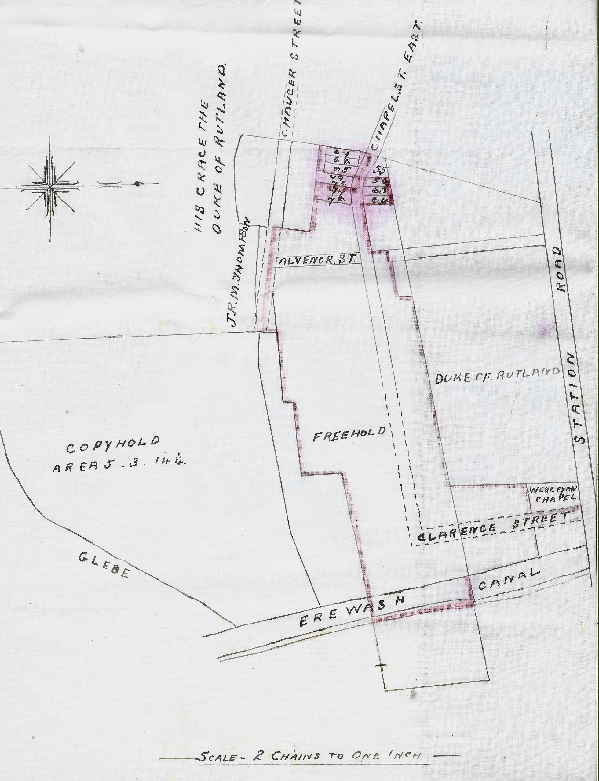
Station Road (1881-1899)
Robert Knighton Skevington (aka Robert Skevington Knighton) was a Cotmanhay farmer who, in 1881, owned a portion of land known as “Pithills” (also referred to as “Barn Close” in documents). This land once stretched from what was later known as Lower Chapel Street northwards to Wash Meadow and had been in the hands of Robert’s family at least since the enclosure of Ilkeston land in the 1790s. On November 2nd, 1875 the property was enfranchised by Robert.
Because of financial difficulties he was forced into bankruptcy and obliged by his creditors to sell this land in 1881, and in this way some of his property was bought by Charles Hiram Gregory, landlord of the Wine Vaults in East Street. It was described as being of 376 square yards, “on the south side and abutting upon Station Road” and “on the east side of a plot of land marked Lot 8” and helpfully within the documents there was a sketch plan to show this (below)
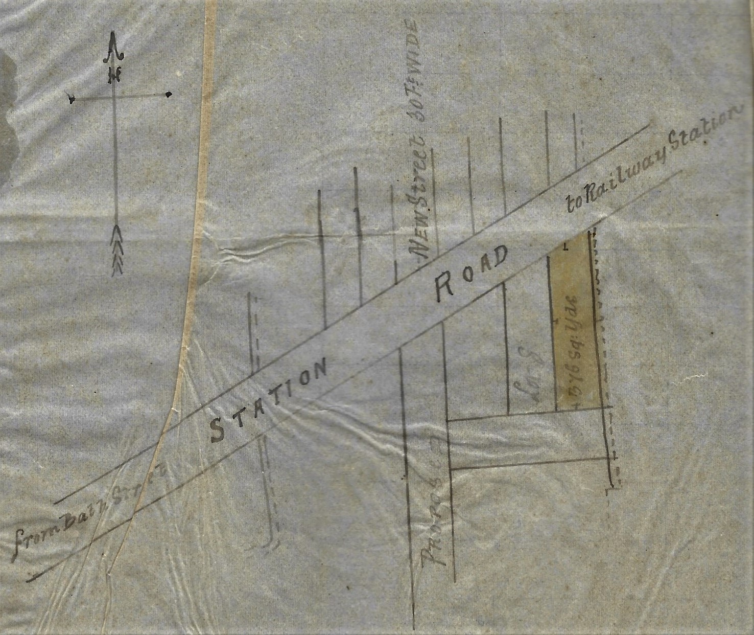
Its precise location wasn’t shown as the proposed new street crossing Station Road hadn’t yet been built and therefore wasn’t named. In 1882 Charles mortgaged this property with Nottingham banker Henry Abel Smith.
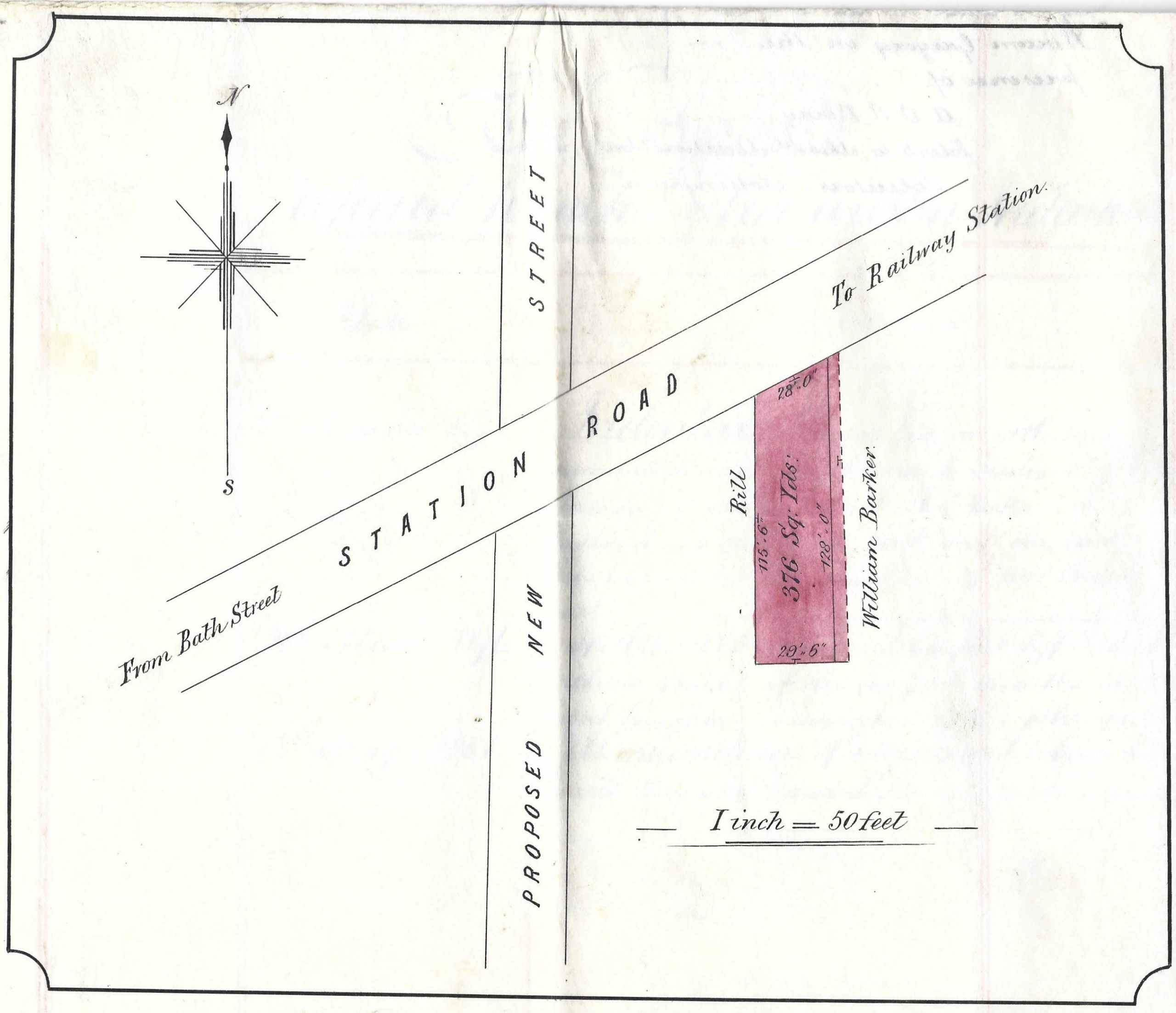
And then, on November 8th, 1882, the premises shown in the plan above were conveyed by Charles Hiram Gregory and his mortgagee to lacemaker Frederick Henshaw. Again there was a sketch plan, much like the previous one, showing the size and neighbours, but no precise detail of where the property was (see below)
 On November 29th, 1882 Frederick took out a mortgage with the Rutland Lodge Friendly Society No 23 in the Nottingham Ancient Imperial United Order of Odd Fellows at the King’s Head, whose trustees were lace manufacturer William Ball the Elder and butcher John Mellor. At that time Frederick had started to build two houses on the land.
By 1886 the “proposed new street” crossing Station Road had been christened as King Street, and in that year and again in 1893 Frederick took out further mortgages with the same Friendly Society. Frederick’s two houses fronting onto Station Road had been numbered 105 and 106. Frederick was living at 105 with his family.
On September 25th, 1897 the property was reconveyed to Frederick and two days later he sold the two houses to William Bonsall. At that time number 105 had a butcher’s shop attached, occupied by Ann Barnes (nee Briggs), the recent widow of William Barnes and the daughter of South Street watchmaker William Briggs.
On August 11th, 1898 William Bonsall mortgaged the property with Thomas Sisson of Heanor Road, and then on February 4th, 1899 the pair sold the property to Robert Widdowson, a grocer of Old Basford.
______________________________________________________________________
Stanton Road (1879-1982)
The story in this batch of documents begins on July 4th, 1879 with the interest in the property off the west side of Stanton Road (shown below) of Job Nightingale Simpson Derbyshire. They outline what happened to the premises after Job died in 1886 and then his wife Mary (nee White) died in 1888; of how they were the responsibility of the eldest son Samuel Patrick Derbyshire.
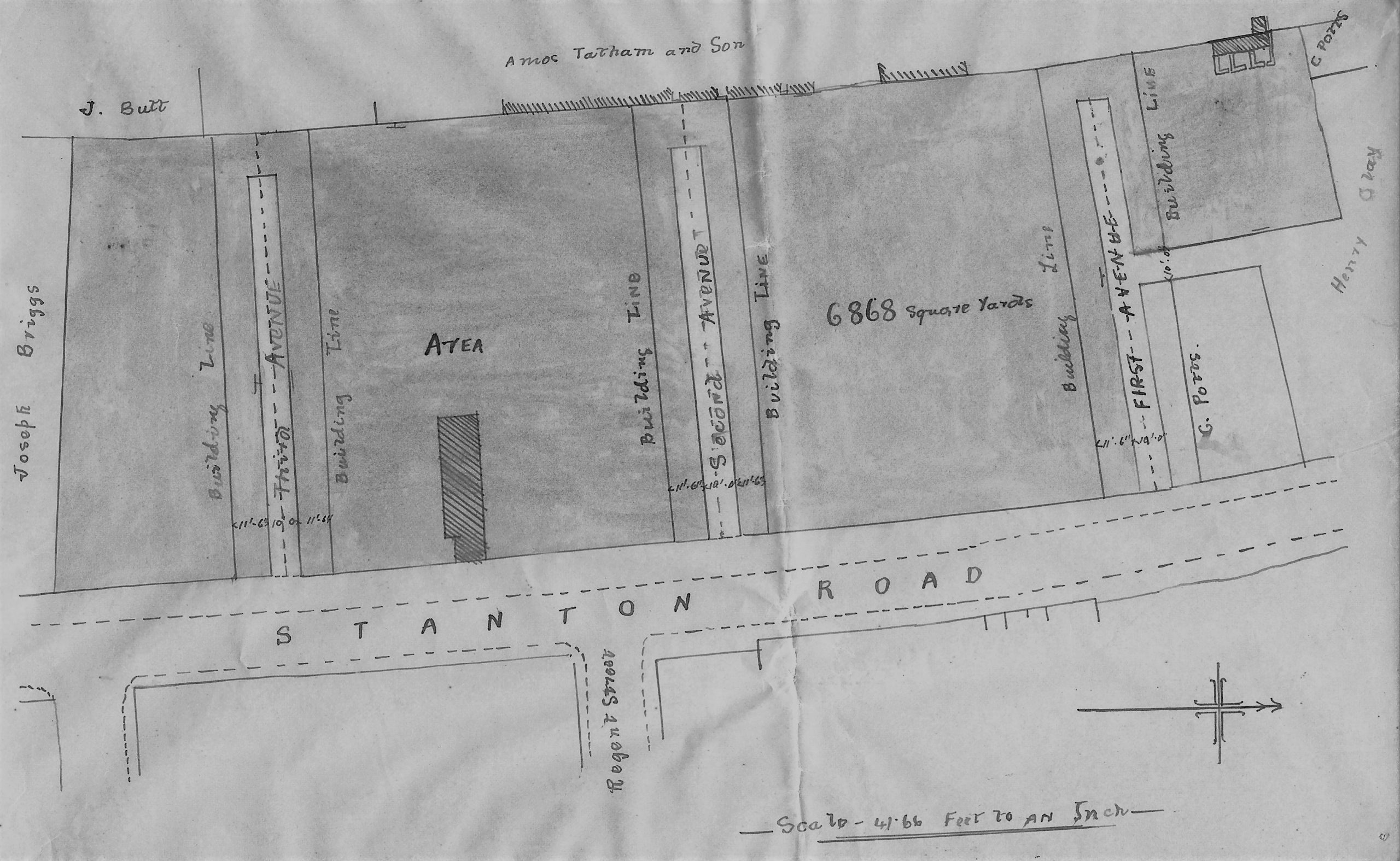
From March 1893 First Avenue was developed along with the prospective Second and Third Avenues. The sketch map above shows the people who held an interest in this area’s property. You should spot the names of Henry Clay, Charles Potts, Amos Tatham, James Butt and Joseph Briggs.
The following sketch map shows the same area in June 1897 when some new names have been added.
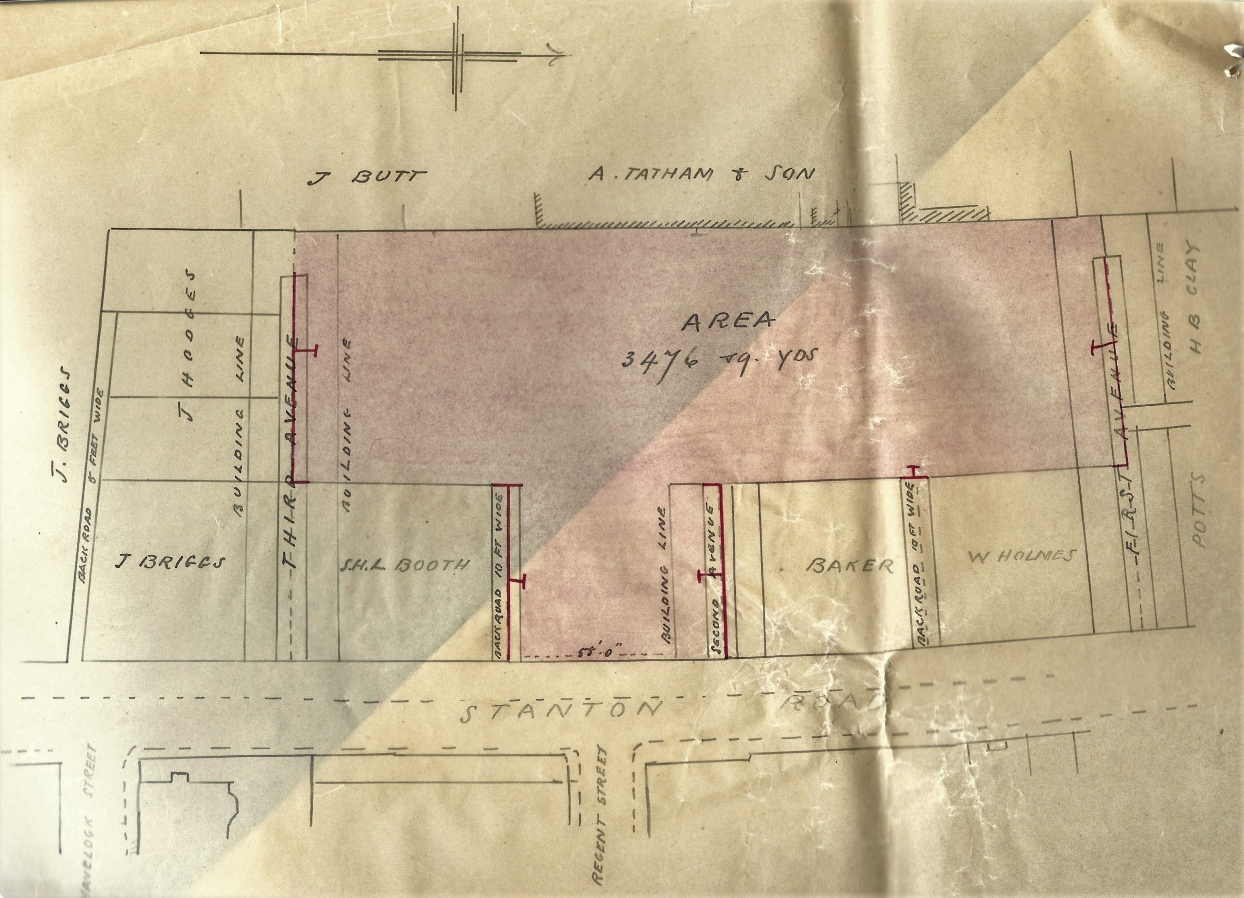
In 1897 Ilkeston builder Walter Scott had taken over several properties in the area and in 1899 parts of these were mortgaged by different parties, as the plans below show.
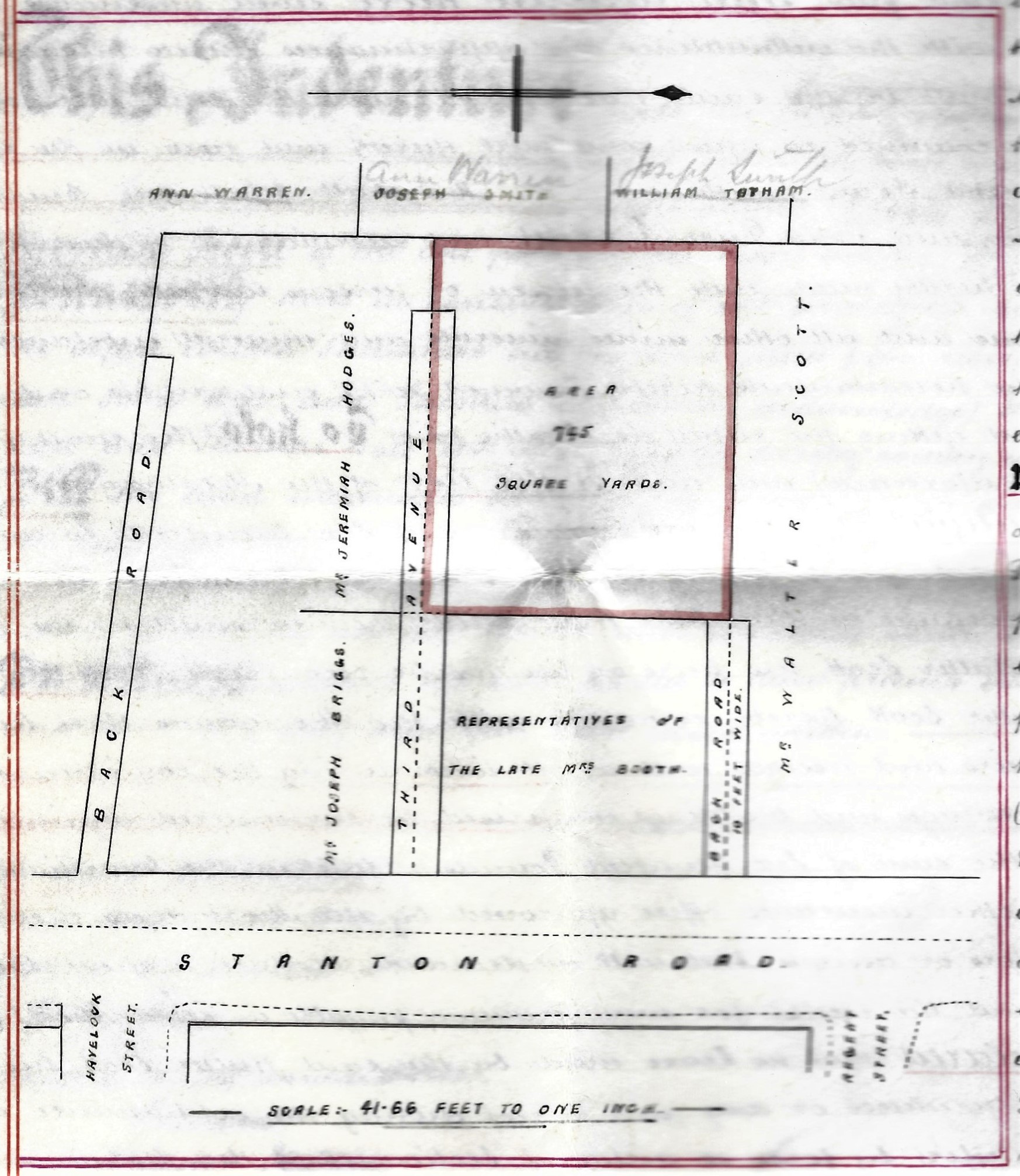 1899: Plan of Third Avenue showing the area mortgaged by widow Eliza Ball of Heanor, John Ball of Codnor and Thomas Ball of Heanor
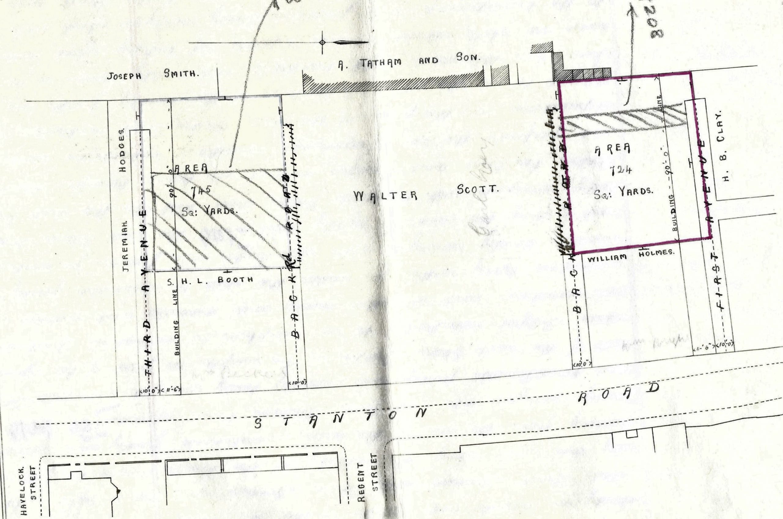
1899: Plan of First and Third Avenues showing the areas sold by Walter Scott to Clara Horton of Ilkeston
This latter plan shows seven premises in First Avenue and seven in Third Avenue which, in the same year, passed from Clara Horton to Benn Booth Gilbert of Alfreton. The later died in 1906 and his interest in the properties passed to other members of his family and eventually back to Clara Horton in 1922.
Clara Horton died in 1945 and via her will’s sole executor, solicitor George James Lee, the houses in First and Third Avenues were sold to the Lally family in 1947 and remained with them until 1982.
______________________________________________________________________
Vernon Street (c1899-1902)
In the latter half of the Victorian era, William Beardsley (1808-1878) and then his sons Joseph (1831-1909), William junior (1834-1918) and Ezekiel (1845-1924) built a firm of lace manufacturers based around Primrose Street in Cotmanhay and known as William Beardsley and Sons. At the end of the nineteenth century the sons owned a piece of land off the east side of Cotmanhay Road. It measured 1600 square yards and was part of a larger area of four acres which went by the name of Back Close. On its west side was land owned by William Barton; on the east and south was more land owned by the Beardsley sons; and on the north was the proposed site of a new road called Vernon Street which had not yet been laid out.
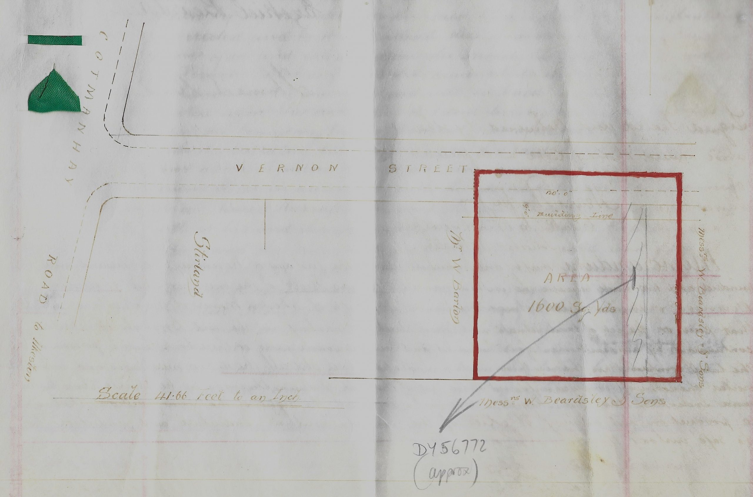
Vernon Street site in August 1902
You might be able to note these features on the very faint plan above, drawn up in 1902. You might also see the name of Stirland on the left of William Barton’s plot — this was Herbert Stirland, postmaster and grocer at 239 Cotmanhay Road. And opposite the proposed site of Vernon Street was the Trumpet Inn on the other side of Cotmanhay Road.
On August 16th, 1902 the Beardsleys sold their area of 1600 square yards to Thomas Reeve, builder of Alvenor Street (see Roberts Street above). In their agreement both sides undertook to play their part in the development of Vernon Street. Within a couple of months, by November 1902, Thomas Reeve had built several houses on the street which he promptly sold in batches, to miner William Stevenson, miner Amos Henshaw and miner William Thomas Morley. And then in the following month, on December 23rd, he sold a further two houses to his old pal Frederick Gregory of Mill Street.
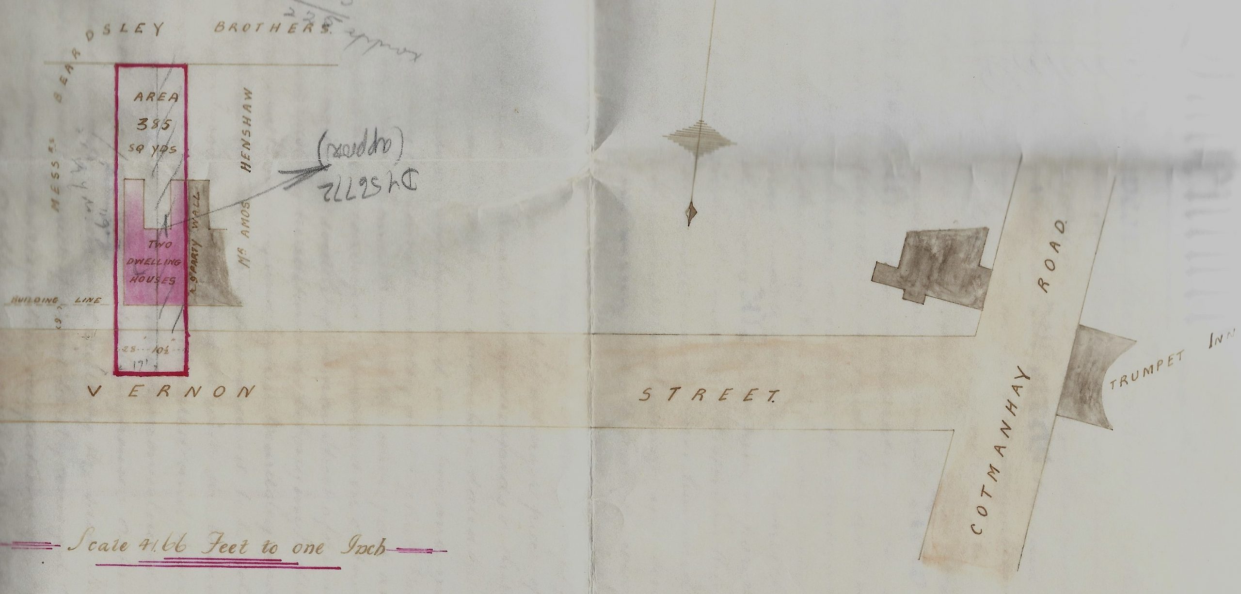
Vernon Street site in December 1902
Clearly marked on the sketch plan above is the plot conveyed to Frederick Gregory. The neighbour to the west is Amos Henshaw. Note also the site of the Trumpet Inn and the premises of Hebert Stirland at 239 Cotmanhay Road.
No sooner had Frederick Gregory got his hands on the property than he took out a mortgage with draper Henry Thompson of 12 Bath Street. The property was reconveyed to Frederick by Henry on February 7th, 1919. And a few days later, on February 10th, Frederick sold the property to Arthur Watchorn, the landlord of the Anchor Inn in Market Street.
______________________________________________________________________
Now on to Old Ilkeston Streets 2 ? ….or 3?
