The year is 1866 … almost 30 years since Victoria became Queen of the United Kingdom, with another 35 years (approximately) to reign. We have completed just over two-thirds of our journey around the town, and have now arrived back at the Market Place, having just walked along East Street.
Let’s take a breather outside the Town Hall. …. X marks the spot !!
We will use the Local Board map (below) to help us summarise what we have seen so far, and who we have met.
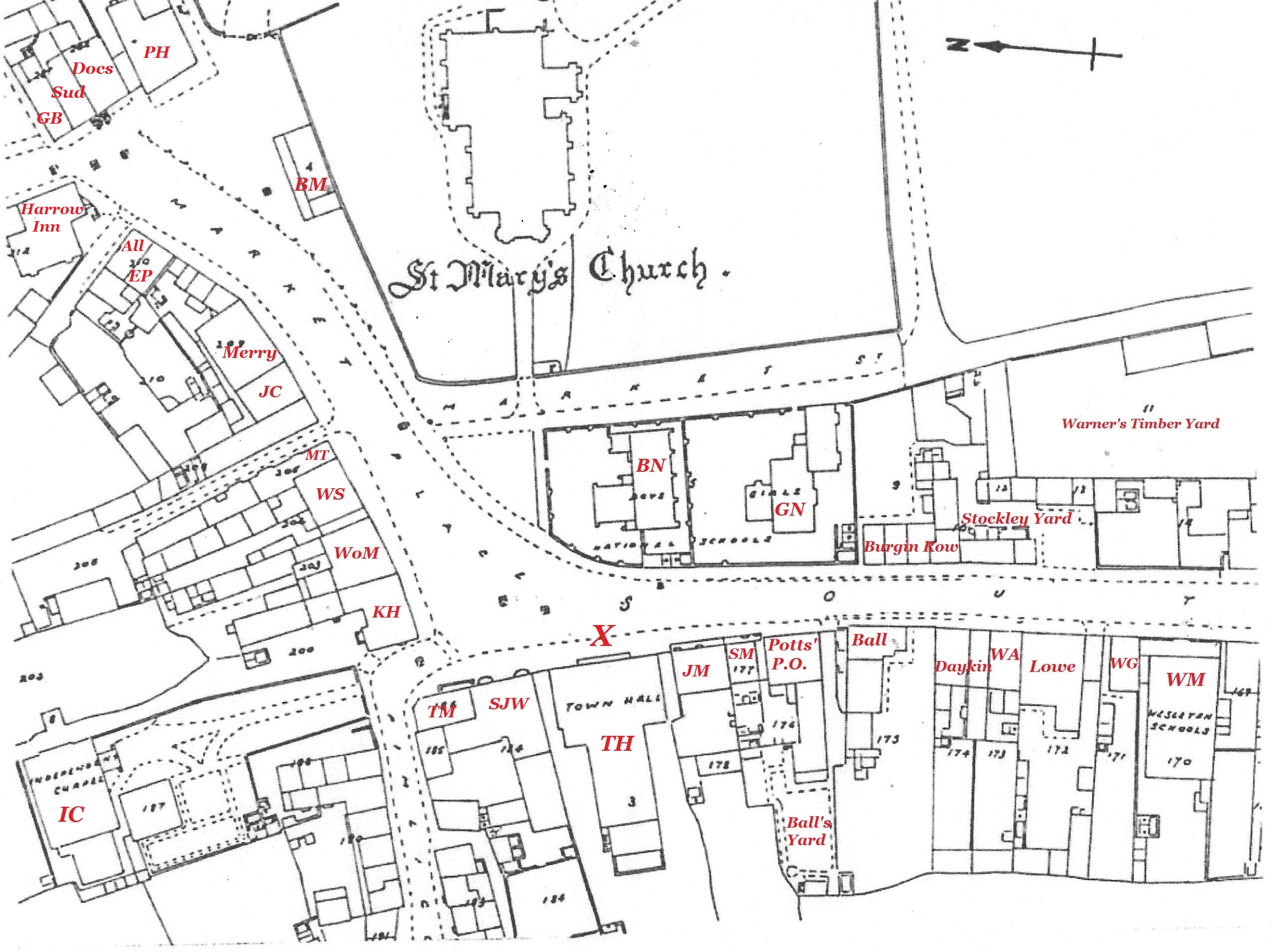
Adapted from the Local Board map of 1866
Along South Street to Pimlico
On our way to the Town Hall, we have just passed the brand-new Wesleyan Sunday schoolrooms, (WM) standing back a little from the roadway, opened in 1865. And, ironically, in that same year, we sadly saw the last of its neighbour, William Gregory, (WG) who used to own the orchard on which the schoolrooms were built, and who died on 26th February, 1865.
At this point, if we look across South Street, we can see, to our right, Burgin Yard, then Stockley Yard in front of Warner’s timber yard, and finally, to our left, Burgin Row.
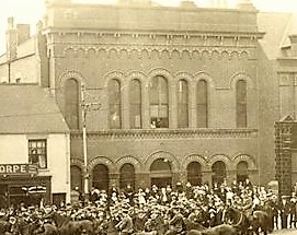
Above, we can see the distinctive facade of the Wesleyan Sunday School rooms in 1914 (Courtesy of Ilkeston Library)
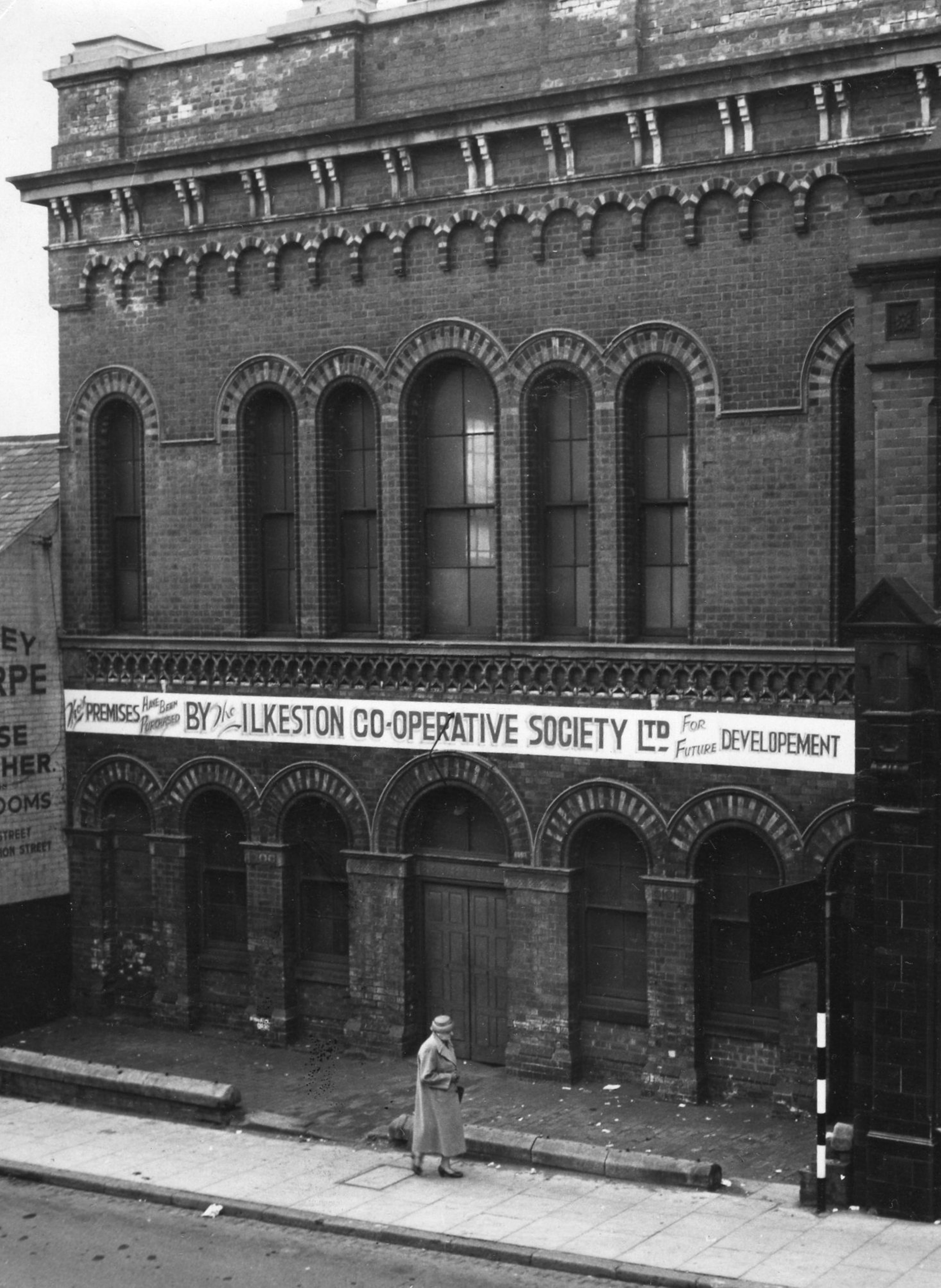
Right are the School rooms in October 1957 (Ilkeston Library)
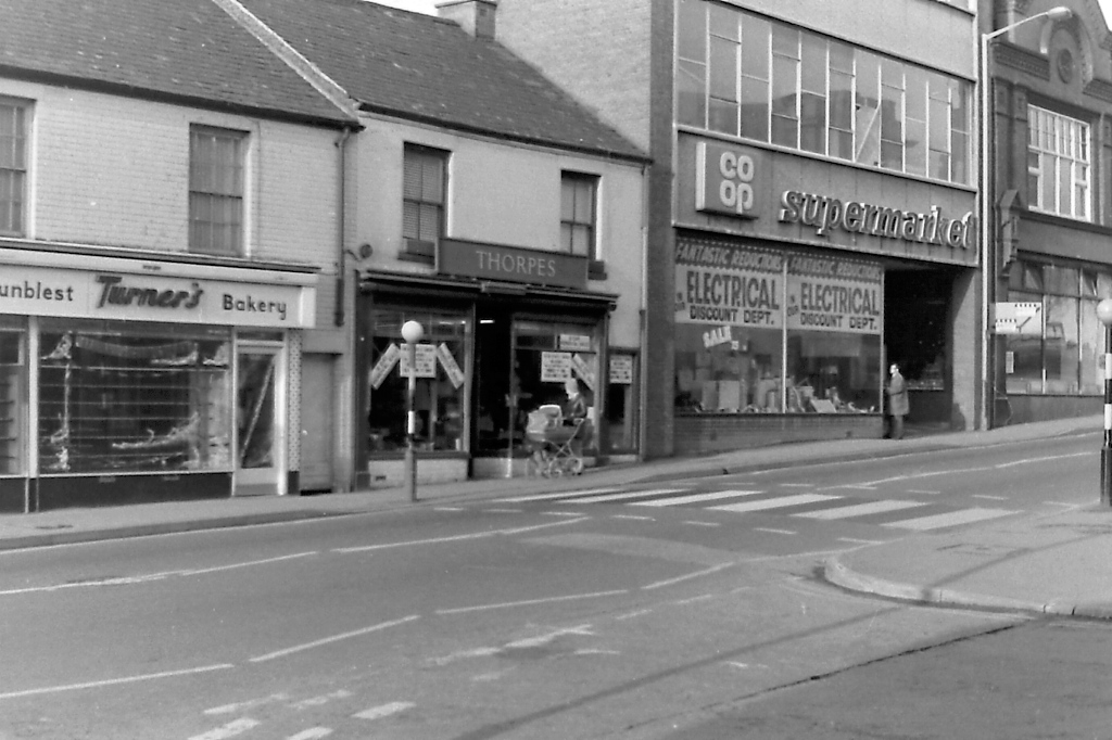
The 1960s and the School rooms are gone, replaced eventually by the Ilkeston Co-op buildings, but Thorpes are still there !!! (Jim Beardsley collection)
The photo is taken from Coronation Street, the site of what was Burgin Yard, mentioned above.
We then passed the grocery business of Samuel and Mary Lowe, William Armstrong’s furniture shop (WA) and Daykin’s grocer’s shop and house. This brought us to the premises of the Ball family, pork butchers, and the entry to Ball’s Yard, containing two cottages where some members of that family lived.
On the other side of the entry to the yard was the “General Post Office”, home to postmaster, chemist, druggist and grocer, Richard Smith Potts and his family.
And next was the cottage which housed the Boys’ National School master (SM). On New Year’s Day of 1866 this school master was John James Spendlove who died of consumption in his South Street home on January 20th; his place was then taken by A. G. Hughes. Neither had very far to walk to get to work …. as you can see from the map.
And then we saw the home and shop of butcher John Mellor (JM)… on every census until his death in 1892, John appears at this house, although, from the end of 1865, he shared the site with the Ilkeston branch of the Nottingham Joint Stock Bank (Limited).
This brought us to the Town Hall (TH) where we take our rest. And here’s a puzzle for you !!
Work to build the new Town Hall began at the end of June 1866, though the Hall’s foundation stone was laid three months later, on 27th September 1866 by the Duke of Rutland. The work was completed well within two years and the official opening of the building was on 6th February 1868.
Meanwhile work on the Local Board map of Charles Sherwood Newman began in October 1865, was completed by October 1866; the map was then displayed in November of that year — just one month after the Duke of Rutland had laid his foundation stone !!
How come the Town Hall appears on the map ? By the time the map was drawn up, work on the Town Hall was only just over three months old.
As we stand at the Town Hall we can look across the Market Place towards St. Mary’s Church. After 21 years as Vicar of the parish, the much-loved Rev. George Searl Ebsworth left in 1863 and has been replaced by James Horsburgh. Our gaze to the church is not uninterrupted however, as almost in our line of sight is the Boys’ National School building, (BN) another relatively new building, opened only five years ago. And if we glance right, from that school, we can see its companion Girls’ National School (GN) built in 1851, standing separate. Both schools have their own school yards, and together they present a rather cluttered aspect to almost the whole of this part of the Market Place.
Bringing our gaze back to where we stand, on our left is the first of a series on inns which borders the Market Place — the Sir John Warren, (SJW) established at the end of the previous century and now occupied by Isaac Attenborough and his family. And attached to this and before we arrive at Pimlico — a narrow street which leads off at a right angle in the corner of the Market Place — there stands a small house and shop, tenanted by tailor and draper Thomas Mather. (TM)
If we glance down that opening into Pimlico we can see, in the near distance, the Independent Chapel (IC) with its grounds before it — these once enclosed the small chapel burial ground.
From Pimlico to the Old Harrow Inn
Having now sufficiently rested, we can walk on from the site of the Town Hall, past Pimlico and onto the north side of the Market Place.
The first property we encounter is another inn — the King’s Head (KH) which had two landlords in 1866 — William Woodroffe and then Charles Turton.
For many years the next premises, a grocer’s shop, had been occupied by the Marshall family, and by 1866, it was in the hands of Wolstan Marshall (WoM). At this time he was experiencing financial, marital and all other sorts of difficulties, so that in the following year he sold up and ‘shipped out’; into the shop moved Wolstan’s nemesis, John Wombell, printer and proprietor of Ilkeston’s main (and often only) newspaper, the Ilkeston Pioneer. John was not a grocer of course and so started to make ‘alterations and improvements’ to the property, to adapt it to his own business … and this enraged his next-door neighbour, William Smith. (WS)
Tailor and draper William Smith arrived in Ilkeston about 1862 and occupied this shop which had long housed a drapery; since the beginning of Victoria’s reign it had been in the hands of the West family, until the death of widowed matriarch Hannah West in 1861 and that of her son, George Small West, in 1862.
The final property in this row was another inn !! — the Market Tavern (MT), occupied by Jerry Wigley and originally fronted by the millinery shop of Jerry’s unmarried daughters …. that is until a couple of them decided to get married.
Walking across the alleyway at the side of the inn, on the other side we encounter a second property owned by Jerry Wigley, with John Wombell’s printing works on the upper floor — that is, until the latter moved “up Market” !!
Next was, until recently, the premises of glass and china dealer John Childs (JC) and his wife Elizabeth who traded as a dressmaker and milliner there. In the early 1860s the couple left these premises to trade in Bath Street, and into his shop, or at least part of it, moved butcher William Sudbury, though he did not live at the premises. Gazing over the Market Place we can see the old Butter Market, (BM) which once served as a prison and school, and where, when the weather was fine, John Childs would display his china wares.
The Merry family traded at the next property — styled as grocers, chemists, druggists and ironmongers.
In between this and two new shops further along there were small properties, with various short-term occupants.
And this brings us to these two new shops built and owned by Abraham Greaves, a chemist and druggist from Ironville.
The first shop in line had been tenanted by watch and clockmaker Edwin Wragg, but by 1866 he was esconced in prison. It was still owned by Abraham but was now occupied by Eliezer Pickburn (EP), a brazier and tinman.
And its neighbouring shop had housed Abraham’s business which was managed by Walter Allsopp (All).However by 1866 Walter was its owner, having bought that business from Abraham in 1865. For many years thereafter, it served as a chemist and druggist.
Finally we arrive at the Old Harrow Inn, in the hands of the Aldred family, and separated from Abraham Greaves’ shops by a footway which led to the Harrow Inn Yard at the rear of the premises.
The East side of the Lower Market Place
From the Old Harrow Inn corner, we could walk across Bath Street to the east side of the Market Place, to a short row of buildings. The first belonged to pork butcher George Bunting (GB); this property looked out onto both East Street and the Market Place.
For many years George’s neighbour in the second house was tinner and brazier Pat Pollard. However directory records suggest that by 1866 he had left this shop to trade in either Bath Street or South Street. Adeline Wells writes that the house was then taken over by Francis Sudbury and Elizabeth Bennett (Sud) who had recently (April 24th) married — this was their ‘first married home’.
The third house in this row was locally known as the ‘Doctor’s House’ (Docs) because this is where the town’s doctors often lived !!! In 1866 it was occupied by the practice of William Campbell and William Date.
And last in this row, at the corner of Anchor Row, was the property of grocer, provision dealer and corn miller Paul Hodgkinson. (PH).
——————————————————————————————————————–
And we are ready to continue our town walk … now down the west side of Bath Street
