Adeline Wells was born Elizabeth Adeline Columbine in East Street, Ilkeston, on Monday, October 2nd 1854 and lived in the town until she moved to Nottingham with her family about 1879. Towards the end of the century, with her husband and son, she moved to live in Eastbourne, Sussex, where she spent the rest of her life.
In March 1933 Adeline contributed an article to the Ilkeston Advertiser with the title ‘The birth of a street‘ in which she imagined the development of Bath Street. After describing the growth of Ilkeston from the fifth to the twelfth centuries in about a dozen paragraphs, she continued to describe the town’s main thoroughfare.
“The track up the hill was in a very bad state, and the people made great complaints about it. At last the gradient was made easier, and the track itself had stones laid upon it which were fastened together by a rough cement. This path was called ‘The Caussey’. One or two houses were built on the bank and the track was called ‘The Strait’, which soon developed into ‘The Street’.
“In the eighteenth century the banks were once more cut back, the caussey widened and footpaths made, and ‘The Street’ became ‘The Town Street’.
“About 1830, an alkaline mineral spring was discovered, and it was hoped that the town would become a spa like Matlock. So baths were erected. Hives’ Inn was enlarged and called Hives’ Hotel. (Later the Rutland Hotel) The Town Street was re-named Bath Street, and everyone was in readiness for the expected influx of invalids and otherwise, who would take the waters. But alas! Their expectations were not realised, so the Baths were closed and the Bath House became a private house”.
“Bath Street was originally 68 feet wide, and in consequence of the gradient being a steep one, a cutting was made sufficiently wide to suit the traffic of the day.
“Heanor road was set out 68 feet wide — sixty feet for the pedestrian and vehicular traffic, and eight feet for a ditch of four feet on each side, to drain the road”.
(from a letter to the Ilkeston Pioneer, May 4th 1917, by Joseph Shorthose of Church Street.)
“I remember when Ilkeston was such a quiet countrified place that I could say who lived in every house in Bath Street and South Street. Alas! it is very much altered. Bath Street in 1850 was very different to the Bath Street of today. In Bath Street one could walk along without any fear of being jostled”.
And this (below) is what the Ilkeston News of 1855 thought of Ilkeston and its future.
As we walk around the town we may see if the newspaper’s prophecy was to materialise.
————————————————————————————————————-
Below is a map showing the first part of our journey, from the bottom of Bath Street, past Station Road (formerly known as New Street) and Chapel Street, and up to the old Queen’s Head Inn. The places we will visit are numbered and the map is a 20th century edition (to help you locate where these places would be today). You will realise that many of the roads, streets and yards as well as the properties shown on this map didn’t exist as the Victorian age opened in Ilkeston.
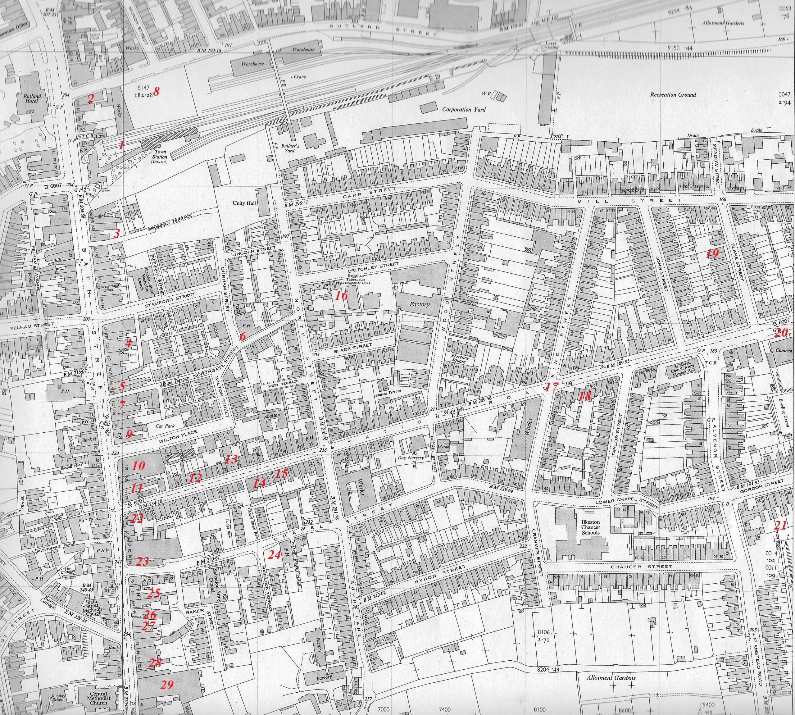
1 is the Town Station
2 is the home of James Chadwick and family
3 shows Brussels Terrace and 4 lies in open fields where stood the Butcher Twells’ shop and field
5 is home to, William Riley, the unfortunate butcher
6 is where we find John Trueman and the Durham Ox
7 is home to the candle maker: Moses Mason and family
8 is the site of the first Gas Works
9 is the Brunswick Hotel and we cross over to 10 which takes us to Wilton Place and the Woolliscrofts
11 is at Station Road corner while 12 is a little further along at Riley’s Row
13 is the factory and home of Henry Carrier
14 houses Samuel Wood, grocer and baker and 15 is neighbour Enoch Carrier
16 lets us explore Housing at Pigsty Park
17 and 18 take us on to new housing in Station Road and then 19 which shows us more building in Station Road 1881-1901
20 is where we find a Station Road Suffragette as we go beyond North Street
21 introduces us to Brickmaker Samuel Shaw
22 and we are back to east Bath Street to meet William Tarlton while 23 takes us to meet others before we go to Chapel Street
24 explores into Chapel Street and includes the Flower Pot beerhouse
25 is the site of the Prince of Wales beerhouse
26 explores the short life and the tale of George Clay Smith
27 is where we meet tailor Thomas Wass and his neighbour, the London House of Kitty Beardsley
28 introduces us to the Allcock sisters
29 leaves us at the Queen’s Head Inn
————————————————————————————————————-
And so we set off , up the east side of Bath Street (that is, on its left side), and this is what lies before us. You can just see St. Mary’s Church in the far distance (middle)
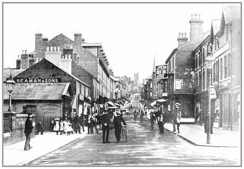
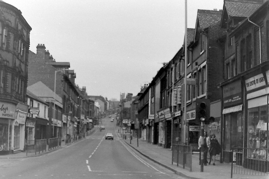
Or do you prefer fewer pedestrians ?
————————————————————————————————————-
We begin at the Town Station at the bottom of Bath Street. (that is, approximately to the left of the photographer !!) Home Page
